kansas methodism 
    Some Historical Background
    A Tale of Many Conferences
    The many configurations of the Conferences (administrative areas) of the Methodist Church in Kansas 1856-1939
    click here to view a text version
    1856
    Click on the Image to view a larger graphic
    In 1856 the Kansas and Nebraska Conference was to embrace the Kansas and Nebraska Territories, and the part of the territories of New Mexico and Utah that were east of the Rocky Mountains.
    1860
    Click on the Image to view a larger graphic
    In 1860  the Kansas Conference included the State or Territory of Kansas, and the State of Texas, and the part of New Mexico east of the Rocky Mountains. 

    In 1864 the Kansas Conference was reduced to only the State of Kansas. 

    In 1868 the Kansas Conference was expanded again to include the State of Kansas and the Indian Territory. 

    In 1872 the Kansas Conference was the State of Kansas and only that part of Indian Territory north of the 36th parallel of north latitude.

    1876
    Click on the Image to view a larger graphic
    In 1876 the state was splint into two Conferences.  The Kansas Conference was north of the south line of township 16, (including the town of Pomona), but left Louisburgh, Ottawa, and Baldwin City, which were north of the line, in the South Kansas Conference.  

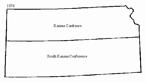
    In 1877 only Baldwin City of these towns belonged to the South Kansas Conference. 

    In 1876 the South Kansas Conference was all the rest of  the State of Kansas not included in the Kansas Conference, and as much of the Indian Territory that was north of the 36th parallel of north latitude. 

    In 1880 the South Kansas Conference no longer included Indian Territory.

    1884
    Click on the Image to view a larger graphic
    In 1884 Kansas was split into four Conferences.  The Kansas Conference was east of the sixth principal meridian and north of the south line of township 16 and included the town of Pomona (not Louisburgh, Ottawa, Baldwin City, or Soloman City)  However Baldwin City remained in the Kansas Conference until the next session of the conference. 

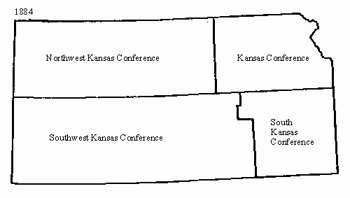
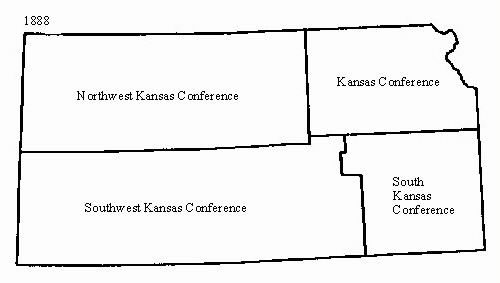
    The Northwest Kansas Conference was north of the south line of township 16 and west of the sixth principle, along with including the Soloman City Circuit. 

    The South Kansas Conference was east of the west line of Chautauqua, Elk, Greenwood and chase Counties, and south of the south line of township 16, and included Louisburgh, Ottawa and Baldwin City (not Pomona).  Baldwin City did not belong the to Conference until after the conference of 1885. 

    The Southwest Kansas Conference was south of the south line of township 16 and west of a line beginning at the southeast corner of Cowly County, then north to the south line of Chase County, and then west to the southwest corner of Chase County and then north to the south line of township 16.

    1888
    Click on the Image to view a larger graphic
    In 1888 the Kansas Conference remained the same except that in 1889 Baldwin City was to return to the Conference. 

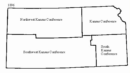
    The Northwest Kansas Conference changed its border to north of the south line of township 17. 

    The Southwest Kansas Conference had the everything that the other Conferences didn't have plus it took in "No Man's Land" (the "panhandle" of  present day Oklahoma). 

    In 1893 Baldwin City moved back to the South Kansas Conference.

    1896
    Click on the Image to view a larger graphic
    In 1896 the Northwest Kansas Conference changed its southern boundary to the south line of township 17 and as far west at the east line of Lane County then north to the north line of Lane Count and then to the state line 

    The Southwest Kansas Conference changed "No Man's Land" to Beaver County in Oklahoma Territory (which changed to Beaver County in the state of Oklahoma in 1908). 

    And finally the South Kansas Conference got to keep Baldwin City. 

    In 1908 the town of Quenemo was added to the Kansas Conference. 

    In 1912 the Southwest Kansas Conference included Beaver, Texas and Cimarron Counties in the State of Oklahoma.

    1916
    Click on the Image to view a larger graphic
    In 1916 the South Kansas Conference ceased to exist and the Kansas Conference eastern boundary became a line east of the west boundary of Chautauqua, Elk and Greenwood Counties, then along the south and west boundary of Chase County to the south and west boundary of Morris County then to the south boundary of Dickinson County; then west to the sixth principal meridian then north to the Nebraska State line (excluding the Soloman City Circuit).
    1939
    Click on the Image to view a larger graphic
    In 1939 the Kansas Conference boundary along the boundaries of Chautauqua, Elk, Greenwood, Chase and Morris Counties stayed the same.  Then it moved to north on the east boundary of Dickinson, Clay and Washington Counties to the State Line. 

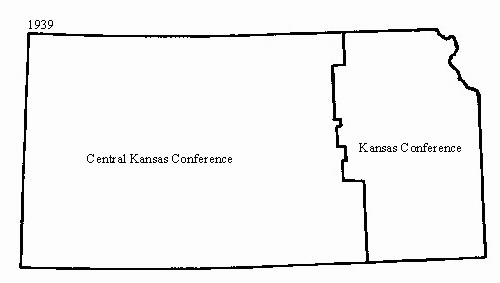
    The Central Kansas Conference was made up of the rest of the State.

    The present naming of the East and West Kansas Conferences along with their present boundaries are being researched at this time.  Upon completion of this research the maps and information will appear here.


    Top of
    Page
    Historical
    Background
    Kansas
    Methodism
    email
    webmaster
    Guestbook Heritage
    Server
    Other
    History
    Links

     This page is maintained by Linda Morgan Clark MTh., a United Methodist ministerial member of First United Methodist Church, Muskogee, Oklahoma, Oklahoma Conference of The United Methodist Church.
    Your suggestions for additions to this site are welcomed. If you find information here that is erroneous, the author welcomes your
    comments. Also, please report any links that aren't working.